Author: Cai Yingkai, Li Yichao, Wang Zhaokui
Journal: Advances in Space Research
DOI: 10.1016/j.asr.2024.02.025
Innovation: Satellite formations play a crucial role in space missions, enabling three-dimensional observations and critical component monitoring. Traditional methods for maintaining and reconfiguring satellite formations rely heavily on precise but complex measurement techniques. This study introduces a novel GNSS-based approach that simplifies the process, enabling real-time, high-precision baseline measurements without the need for precise ephemeris, clock bias files, or historical data.
Methodology: Utilizing single-epoch Global Navigation Satellite System (GNSS) carrier phase difference measurements, our algorithm effectively determines the relative position of satellites in formation. By addressing the limitations imposed by the BeiDou Navigation Satellite System (BDS) GEO satellites and optimizing observation weights, we significantly enhance measurement accuracy. The development of a GNSS-based real-time measurement module, incorporating a custom spaceborne GNSS receiver and robust communication protocols, ensures efficient data exchange and processing within satellite formations.

Fig.1 GNSS-based real-time measurement module.
Ground Experiments and Results: Ground experiments were conducted to validate the methodology under various baseline scenarios, ranging from 10 meters to 9.3 kilometers. The results demonstrated remarkable accuracy, with carrier phase measurement errors consistently below 5 cm, and computational speeds within 0.1 seconds per epoch, even in high-dynamic zero-baseline tests. These findings underscore the potential of our approach in real-world satellite formation applications.
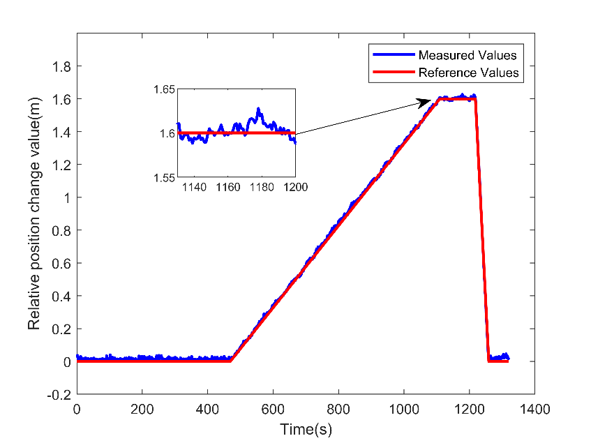
Fig.2 Relative position measurement results.
Simulated Data Testing: High-dynamic scenarios were simulated to assess the algorithm's performance in space-like conditions. The GNSS signal simulator tests further validated the high accuracy and efficiency of the proposed method, indicating its suitability for satellite formation flying in low Earth orbit.
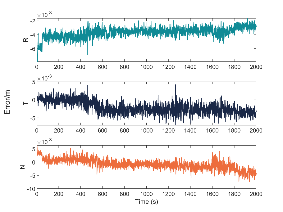
Fig.3 Relative position measurement error based on pseudorange.
Future Implications: Our study not only presents a cost-efficient and scalable solution for inter-satellite relative position measurement but also paves the way for more flexible and robust satellite formation configurations. With the aim of conducting on-orbit experiments, this research contributes to the advancement of satellite formation technology, promising significant impacts on space exploration and monitoring missions.
Conclusion: The innovative GNSS-based approach for real-time, high-precision baseline measurements offers a promising solution for satellite formation flying. By overcoming the challenges associated with traditional methods, this study enhances the flexibility and reliability of satellite formations, marking a significant step forward in space science missions and in-orbit services.
Reference
[1] Cai Y, Li Y, Wang Z. Real-time High-precision Baseline Measurement of Satellite Formation Flying Based on GNSS[J]. Advances in Space Research, 2024. (https://authors.elsevier.com/c/1if-p~6OiwyMM)